Bushfire Alerts in Tasmania: Authorities Issue Warnings for Several Areas
Tasmania is currently facing a significant bushfire threat, with multiple active fire warnings across the state. Authorities have issued 18 warnings and reported 16 fire-related incidents, urging residents and travelers to remain alert and take necessary precautions.
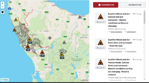
Current Bushfire Warnings
According to the latest updates, several regions in western Tasmania are experiencing bushfire activity. Some of the most affected areas include:
- Renison Bell and Surrounds – Authorities have issued a “Watch and Act” alert, advising residents to monitor conditions as they evolve.
- Reece Dam and Surrounds – The warning here is more severe, with authorities urging people to avoid the area entirely.
- Pieman Heads, Conical Rocks, and Surrounds – While the threat level has been reduced, authorities still recommend monitoring the situation closely.
Fire Hotspots and Risk Areas
The map of active fires shows that the most affected regions include the Meredith Range Regional Reserve, Zeehan, and the areas surrounding Savage River. Several roads in these regions are marked in red, indicating potential fire danger or restricted access due to emergency response efforts.

Safety Recommendations
Authorities are urging people in affected areas to:
- Stay informed through official emergency channels.
- Follow evacuation orders if necessary.
- Avoid non-essential travel in high-risk zones.
- Prepare emergency kits and have a bushfire survival plan in place.
Emergency Response and Outlook
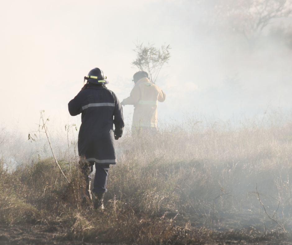
Firefighters and emergency services are actively working to contain the fires and minimize the damage. Weather conditions, including high temperatures and strong winds, may influence fire behavior in the coming days.
For live updates and detailed information, residents can visit official Tasmanian emergency websites or tune into local news broadcasts.
Picture from: Tasmania Emergency Services
Weather Report for Affected Areas
| Location | Weather Conditions |
|---|---|
| Rosebery | Mostly sunny, 8°C, no significant rainfall expected |
| Zeehan | Partly cloudy, 16°C, minimal rainfall (0-2 mm) |
| Savage River | Cool and mostly dry, minimal rainfall expected |
| Sandy Cape | Cool temperatures, dry conditions, bushfire risk remains |
| Hangmans Creek | Mostly sunny, 6°C, no significant rainfall expected |
| Corinna Road | Clouds and sun, 11°C, minimal rainfall (0-2 mm) |
| Violet Rivulet | Cool and dry, minimal rainfall expected |
| Pieman Heads | Cool, limited precipitation, bushfire risk remains |
| Conical Rocks | Cool and dry, minimal rainfall expected |
The Gell River fire is still burning and has destroyed Churchill’s Hut, a historic shelter named after Elias Churchill, the man who captured the last Tasmanian tiger.
A satellite image from January 30 shows smoke continuing to spread over nearby towns. Firefighters were already struggling to contain this blaze, as it had reached rugged and hard-to-access areas. Special remote-area firefighters were flown in to help.
However, things got worse when lightning storms in mid-January sparked even more fires. Many Tasmanians were amazed by the storm and shared pictures and videos of the lightning. But because the state had just experienced its driest January on record, the dry conditions helped the fires spread quickly.
New fires broke out in the Central Plateau and near the Tahune forest. Usually, one bushfire at a time is hard enough to control, but now multiple large fires were burning at the same time. Firefighters had to divide their efforts and make tough decisions on where to focus their resources.
By January 20, the fire near Great Lake in the Central Plateau was already massive. Experts called this an unprecedented event, with 187,000 hectares already burned. At the same time, the Tahune fire was growing out of control. This fire has caused the most damage to communities, forcing hundreds of people in the Huon Valley to evacuate.
Since last week, emergency warnings have been issued almost every day. Firefighters have advised that only people who are fully prepared to protect their homes should stay.
A satellite image from January 30 shows that the Tahune fire had already burned 56,000 hectares, and thick smoke was spreading over towns in the east.
“This fire started naturally with lightning,” said Professor Bowman. “The problem is that we don’t see any significant rain coming soon, and this is the peak of the fire season.”
He reminded people of February 7, 1967, when Tasmania had its worst-ever bushfire disaster, and warned that conditions could still get worse.
“With no rain, the fires will keep getting stronger and bigger,” he said. “This really is a fire crisis.”
External link: https://alert.tas.gov.au/media-releases/media-release-tasmanias-fire-agencies-continuing-bushfire-response
read similar : TPG Telecom’s Power Outage Wreaks Havoc: Services Disrupted Nationwide